
Zoning Use Maps
Zoning Use Maps show the future of our places. They digitize and standardize the residential and nonresidential uses allowed in a given geography.
WHAT ARE ZONING USE MAPS FOR?
Data Integration · City and Regional Planning
Policy Analysis · Site Selection
Zoning Use Maps Overview
Zoning Use Maps offer a standardized overview of the types of residential and nonresidential uses allowed in a given geography, in a raster format.
Existing-land-use datasets from the USGS, NASA, and others describe what's on the ground today—but not what's buildable there. Zoning Use Maps fill that gap. At 30x30m resolution, Zoning Use Maps depict the residential and nonresidential uses permitted under current zoning rules, capturing housing density and 14 nonresidential use types—from retail and office to industrial, institutional, and protected open space—along with roadways, water surfaces, and state and federally protected lands. The result is a ground-truth land classification layer that integrates with existing geospatial environments.
-
Zoning Use Maps offer a digitized and standardized overview of the types of residential and nonresidential uses allowed in a given geography, in geospatial format (API).
Jurisdictions
Counties
Core-Based Statistical Areas (i.e., metropolitan and micropolitan areas)
States
-
30 × 30 meter raster cell
-
Zoning Use Maps are custom-built and can provide information about the following regulatory outcomes:
Residential uses allowed
1-family, 2-family, 3-family, and/or 4+-family housing
Accessory dwelling units
Planned residential developments
Nonresidential uses most relevant to the district, including the following categories:
Agricultural-Industrial
Cultural/Entertainment/Tourist
Industrial
Institutional/Government
Mining/Extractive
Mixed — Any/All Nonresidential
Mixed — Industrial-Commercial Uses
Mixed — Specified Commercial Uses
Retail/Service
Office
Open Space/Light Recreation
Research/Tech
Retail/Service
Transportation
Utilities
-
GeoTIFF
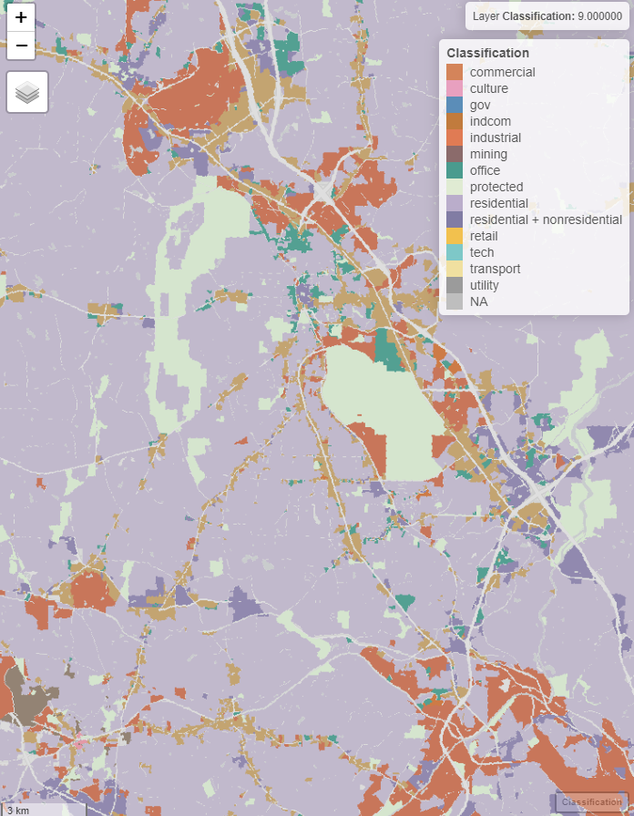
Sample Zoning Use Map
Zoning Use Maps are provided in geospatial format to enable integration into client workflows and analysis. The following image represents a sample of a Zoning Use Map created using our residential and nonresidential categories.
Pricing Quotes Available Now.
This product will be ready for delivery on or before April 1. Contact us using the form below to receive a quote (and to inquire about academic rates).
Interested in Zoning Use Maps?
Fill out the details and we’ll get back to you with a quote ASAP.
Interpreting Zoning Use Maps
Zoning Use Maps rely on a common understanding of the zoning classifications we use across all of our products. Consult our glossary and our explanation of nonresidential use classifications to learn more!
Long live accessible zoning data for everyone.
By licensing our data, you support the National Zoning Atlas.
Land Use Labs is a mission-driven social enterprise created to ensure the NZA — the country's most authoritative zoning resource—stays current, free, and available to all.